
Project Page: City Reconstructions
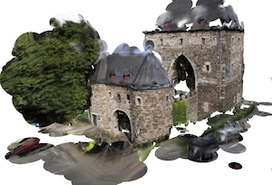
The City Reconstructions smartphone app allows you to three-dimensionally reconstruct any building in your city in a simple and intuitive manner. Just select the building you want to reconstruct on a city map and take some pictures. These get uploaded to our central processing server that fully automatically reconstructs the buildings geometry in the form of a 3D point cloud.
After only a few minutes, the point cloud can be interactively examined within the app. This visual feedback helps you to easily identify missing geometry and to complete the reconstruction by adding further images.
To facilitate this even further, the processing server additionally computes a textured polygon mesh from the point cloud and the uploaded images. This mesh can also be viewed within the app and provides a more intuitive and complete visualization of a building compared to the unstructured point cloud.
![]()
Publication
The back-end of the City Reconstruction app is presented in our publication A Scalable Collaborative Online System for City Reconstruction. It won the Best Paper Award at the ICCV Workshop on Big Data in 3D Computer Vision in 2013. Please cite this paper if you refer to the City Reconstruction app in your publication.
Feedback
We are grateful for feedback! Please send suggestions, bug reports, questions and comments to Sven Middelberg.
